
Wildcat Watershed
Watersheds: Wildcat
Wildcat Watershed
Click to enlarge
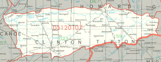
The Wildcat Watershed drains about 515,000 acres in central Indiana. The watershed is centered around Wildcat Creek, whose three forks flow in a generally westerly direction from as far east as southwest Grant County and northwest Madison County toward the creek's confluence with the Wabash River near Lafayette. The Wildcat Watershed drains most of Clinton County and Howard County, as well as parts of five other counties.
County |
Acreage |
Source: USDA
After joining the Wabash, waters from Wildcat Patoka River make their way to the Ohio River and thence into the Mississippi River and on to the Gulf of Mexico.
The United States Geological Survey has assigned the Wildcat Watershed an 8-Digit Hydrologic Unit Code of 05120107.