
Upper Maumee Watershed
Watersheds: Upper Maumee
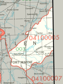
Upper Maumee Watershed
The Upper Maumee Watershed drains about a quarter million acres, roughly half in Indiana and half in Ohio. The watershed begins at the confluence of the St Joseph and St Marys Rivers in Fort Wayne, and flows in a generally northeastern direction toward Defiance, Ohio, which marks the end of the Upper Maumee Watershed. Almost all of the Upper Maumee watershed in Indiana lies in Allen County, but it also drains a small portion of extreme southeastern DeKalb County. Black Creek, Gar Creek and several named ditches are among the Indiana tributaries of the Upper Maumee River.
Acreage |
Source: USDA
The Maumee River flows into Lake Erie at Toledo, Ohio. Lake Erie's water eventually makes its way to the Atlantic Ocean via Lake Ontario and the St Lawrence River.
The United States Geological Survey has assigned the Upper Maumee Watershed an 8-Digit Hydrologic Unit Code of 04100005.