
St Marys Watershed
Watersheds: St Marys
St Marys Watershed
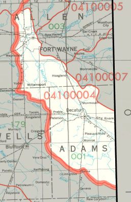
The St Marys Watershed drains part of Indiana and Ohio. The watershed is centered on the St Marys River (no apostrophe, apparently), which rises in western Ohio and flows in a generally northwestern direction toward Fort Wayne, where it joins the St Joseph River to form the Maumee River. In Indiana, the St. Joseph-Maumee Watershed drains most of Adams County, parts of Allen County, and a small part of Wells County. The watershed drains about 244 thousand acres in Indiana, and a slightly larger area of Ohio. Blue Creek and Yellow Creek are significant tributaries in Indiana, along with several named ditches.
Acreage |
Source: USDA
The St Marys River joins the St Joseph River in Fort Wayne, forming the Maumee River. The Maumee passes through Toledo before discharging into the western end of Lake Erie, whose waters eventually flow to the Atlantic Ocean.
The United States Geological Survey has assigned the St Marys Watershed an 8-Digit Hydrologic Unit Code of 04100004.