
Middle Wabash-Deer Watershed
Watersheds: Middle Wabash-Deer
Middle Wabash-Deer Watershed
Click to enlarge
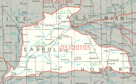
The Middle Wabash-Deer Watershed is in north central Indiana, where it drains about 428,000 acres. It drains most of Carroll County, a large portion of Cass County, and parts of four other Indiana counties. The smaller watercourses in this watershed, including Crooked Creek, Deer Creek, and Rock Creek, drain into the Wabash River.
Acreage |
Source: USDA
The Wabash River flows into the Ohio River. The Ohio then joins the Mississippi River, which empties into the Gulf of Mexico.
The United States Geological Survey has assigned the Middle Wabash-Deer Watershed an 8-Digit Hydrologic Unit Code of 05120105.