
Lower Ohio-Little Pigeon Watershed
Watersheds: Lower Ohio-Little Pigeon
Lower Ohio-Little Pigeon Watershed
Click to enlarge
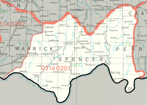
The Indiana portion of the Lower Ohio-Little Pigeon Watershed lies north of the Ohio River in southern Indiana. It drains almost all of Spencer County, much of Perry County and Warrick County, and parts of Crawford County, Dubois County, Pike County, and Vanderburgh County. Altogether, the watershed drains about 633,000 acres of Indiana.
County |
Acreage |
Source: USDA
Little Pigeon Creek drains directly into the Ohio River, as do several other smaller creeks. The Ohio flows into the Mississippi River and then into the Gulf of Mexico.
The United States Geological Survey has assigned the Lower Ohio-Little Pigeon Watershed an 8-Digit Hydrologic Unit Code of 05140201.