
Iroquois Watershed
Watersheds: Iroquois
Iroquois Watershed
Click to enlarge
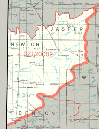
The Indiana portion of the Iroquois Watershed is in the northwestern part of our state, and is centered on the Iroquois River. It drains large portions of Benton County, Jasper County, and Newton County. The watershed drains about 539,000 acres in Indiana, and even more in Illinois.
Acreage |
Source: USDA
Parts of the Iroquois River have been channelized, along with some its tributaries; the latter are often referred to as ditches. Indiana tributaries of the Iroquois River include Hickory Branch, Mosquito Creek, Carpenter Creek, and Slough Creek.
The Iroquois River joins the Kankakee River in Illinois, which then enters the Illinois River, joining the Mississippi River before discharging into the Gulf of Mexico.
The United States Geological Survey has assigned the Iroquois Watershed an 8-Digit Hydrologic Unit Code of 07120002.